Khau Phạ Pass: The Sky Horn of the Northwest
The Pass of the Sky Horn
One of Vietnam’s Four Great Passes
At 30 kilometers in length and reaching an elevation of over 1,500 meters, Khau Phạ Pass is one of the longest and most spectacular mountain passes in Vietnam. It connects the provinces of Yên Bái and Sơn La, forming a natural gateway to the northwestern highlands. The pass is named for its shape — “khau phạ” in Thái means “sky horn” — a reference to the ridge that seems to rise like a horn toward the heavens. The road is a continuous series of hairpin turns, each revealing a new vista: valleys of rice terraces, peaks disappearing into clouds, and the occasional village clinging to the mountainside. It is a road that rewards the traveler with views that change with every season — from the misty mystery of winter to the brilliant green of summer rice.
Above the Terraces of Mù Cang Chải
The Most Photographed View in the Northwest
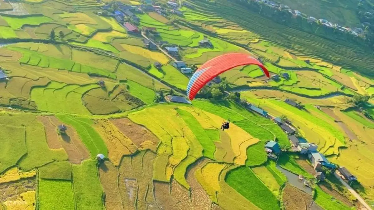
From the heights of Khau Phạ, you look down on the terraced rice fields of Mù Cang Chải — a landscape that has become iconic across Vietnam. The fields cascade down the mountainside in ribbons of green and gold, carved by generations of H’Mông farmers. The best views are from the pass itself, where several viewpoints offer panoramic perspectives on the terraces. In May and June, the fields are filled with water, reflecting the sky like mirrors. In September and October, they turn brilliant gold, ready for harvest. The pass is the perfect vantage point for photographers, and at sunrise or sunset, the light transforms the landscape into a palette of amber and shadow.
The Journey by Motorbike
A Rite of Passage
For motorbike enthusiasts, Khau Phạ is a rite of passage. The road is paved but demanding — the hairpin turns require attention, and the weather can change rapidly. The climb from the Yên Bái side is gradual, with long straight sections that build anticipation; the descent toward Sơn La is steeper, with tighter turns that reward careful handling. The best approach is from the east, with an overnight stay in Mù Cang Chải or Nghĩa Lộ. For those without motorbike experience, many tour operators offer “easy rider” tours, with experienced drivers navigating the pass while you enjoy the views. The journey is not about speed but about the experience: the wind in your face, the gradual change in landscape, the sense of crossing a threshold into the highlands.
Ethnic Villages Along the Route
Life on the Mountain Slopes
The slopes of Khau Phạ are home to H’Mông and Thái villages, their stilt houses and terraced fields carved into the mountainside. Lao Chải and Mù Cang Chải Town are the most accessible bases for exploring the area. In these villages, you can see the traditional crafts of the H’Mông — indigo dyeing, embroidery, weaving — and experience the hospitality of mountain communities. A homestay in a Thái stilt house offers the chance to share a meal, listen to traditional music, and understand a way of life that has persisted for centuries.
The Seasons of the Pass
Four Views, One Road
Spring (February–April): The hillsides burst with peach and plum blossoms, and the terraces are being prepared for planting. The weather is cool, the skies often clear.
Summer (May–August): The rice is planted, and the terraces turn brilliant green. Afternoon rains are common, but the light after a storm can be spectacular.
Autumn (September–October): The most celebrated season — the terraces turn gold, and the weather is mild. This is the peak time for photography and travel.
Winter (November–January): The pass is often shrouded in mist, the temperatures drop, and the landscape takes on a quiet, mysterious beauty. Fewer travelers, but a unique atmosphere.
The Taste of the Highlands
Cơm Lam, Pa Pỉnh Tộp & Forest Herbs
Cơm Lam: Sticky rice cooked in bamboo tubes — the essential meal of the northwest. Available at roadside stalls on the pass, often served with grilled chicken.
Pa Pỉnh Tộp: Grilled fish wrapped in banana leaves with forest herbs — a Thái specialty that is both simple and deeply flavorful.
Thắng Cố: The H’Mông horse meat stew, an acquired taste that has become a symbol of the highlands. Available in Mù Cang Chải town.
Chẩm Chéo: The essential dipping sauce of the northwest — a blend of roasted chili, salt, garlic, and forest herbs that accompanies almost every meal.
Khau Pha Pass Tour Packages
Northwest Loop (5–7 Days): A comprehensive journey through the northwest, including Khau Phạ Pass, Mù Cang Chải, Sapa, and Điện Biên.
Easy Rider Tour: Ride pillion with an experienced local driver, allowing you to focus on the views and the history.
Self‑Ride Motorbike Tour: For experienced riders, with support vehicle and detailed route maps.
Private Car Tour: For those who prefer comfort, a private car with a driver can navigate the pass, with stops at the best viewpoints.
The Essence of Khau Phạ — Khau Phạ is a road that asks you to slow down. It is not a highway to be conquered but a landscape to be absorbed. The hairpin turns, the cloud‑shrouded peaks, the terraces that cascade down the mountainside — all of it invites reflection. It is a road that connects the highlands to the lowlands, the H’Mông villages to the towns, the traveler to the landscape. And it rewards those who travel it with a sense of having reached a place that is both remote and essential — a crossing that has connected the people of the northwest for generations.
Frequently Asked Questions
The pass itself takes about 1–1.5 hours to drive, from the base on the Yên Bái side to the summit and down to the Sơn La side. Allow 2–3 hours total to enjoy the viewpoints and stops.
Early morning (before 9 AM) offers the best light and fewer vehicles. September–October offers golden terraces; May–June offers mirror‑like flooded fields.
The road is paved and well‑maintained, but the hairpin turns and steep grades require experience. Inexperienced riders should consider an “easy rider” tour with a local driver.
Layers — the temperature drops at higher elevations. A jacket, gloves for motorbike riders, sunscreen, and a camera. The sun is strong even in the mountains.
No. Fill up in Nghĩa Lộ or Mù Cang Chải before the pass.
“Khau Phạ” means “sky horn” in the Thái language — a reference to the shape of the ridge, which rises like a horn toward the sky.